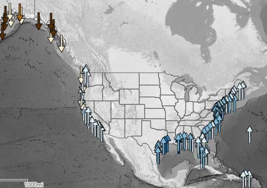
A new interactive map from the Noaa shows the rise in sea level on the coasts of North America. The biggest increase is occurring in the Gulf of Mexico, between Texas and Florida, and not just because of global warming.
Rise is directly related to warming oceans
Global sea level has risen by 15 to 20 cm over the past hundred years. But this rise has not taken place equally or consistently across the different regions of the world. The American organization for the study of the oceans and the atmosphere , the Noaa , has posted a new interactive map to monitor the rise in water levels of the various American coasts, from the southern states to Alaska .
It is estimated that one-third of this rise is directly related to warming oceans, with the other thirds related to the melting of glaciers and ice caps . If the rise is a global phenomenon, it does not occur at the same rate on all the coasts. Other parameters actually come into play: the seismic activity of the seabed, erosion, but also the subsidence of certain lands.
A much faster rise on the coasts of the Gulf States

It is on the coasts of the Gulf of Mexico that the increase in sea level is the greatest (up to 30 cm in Louisiana in 2019), well above the global level. The coasts of this region (Texas, Louisiana, Mississippi, Alabama and Florida) are gradually collapsing because its inhabitants pump water from aquifers (reservoir rocks), in particular on the Mississippi River: as this water disappears , the ground compacts and sinks, while the sea level continues to rise. Oil and gas extractions have the same effect on soil collapse . The influence of the Loop Current , a warm ocean current from the south, also influences sea level rise.
A surprising drop in water levels in Alaska?
The data from the Noaa map may seem startling for Alaska, suggesting that the water level is falling: the land in Alaska is actually rising faster than the water level, so even May the water keep rising! With the disappearance of the last great glaciers of the Ice Age , the land is rising.
According to the Noaa, the climatic phenomena El Niño and La Niña also have an influence. When La Niña is present for several years in a row , it tends to slightly reduce sea level rise on the western American coasts (California, Oregon, Alaska), and the reverse also occurs with a succession of episodes of El Niño. But, as the states of California and Oregon do not have large glaciers, sea level rise continues, balancing itself with the consequences of the La Niña phenomenon: in this area, the increase in sea level water is simply in line with the planetary average.

The waters of the coasts of the northeast of the country (from New York to Maine) rise at a slightly above average rate: here too, the sea level is influenced by the El Niño and La Niña phenomena, but also by the jet stream . During El Niño years, snowstorms are more frequent in the northeast, helping to raise the water level. During La Niña years, snowstorms affect western Appalachia more, without impacting the water level.
By taking into account all these atmospheric and oceanic parameters, in addition to forecasts on global warming , the NOAA estimates that the level of the water will rise as much over the next thirty years as over the past hundred years , that is to say say 25 to 30 cm by 2050.
Source: NOAA


